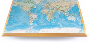
Bird's-eye view of South Milwaukee / from sketches & photographs by the Binner Engraving Co., Milwaukee & Chicago
Sketched map of the South Side of Milwaukee, from "Sketches & Photographs by the Binner Engraving Co., Milwaukee & Chicago", about 1906, reprint.
While the region had been inhabited by Native Americans for thousands of years, the first European known to inhabit the area was French fur-trader Alexis Laframboise, in 1785, who established a trading post in the region. The city of Milwaukee can be traced back to a series of trading posts established by French fur-trader, Jacques Vieau, in 1795. Solomon Juneau purchased the trading post that Vieau had established at the mouth of the Milwaukee River in 1820.
During the 1830's, three settlements emerged around this portion of the river, one being a settlement called Juneautown, founded by Solomon Juneau and his new partner, Green Bay lawyer Morgan Martin, who purchased 160 acres of land between Lake Michigan and the Milwaukee River. Land west of the Milwaukee River was purchased by Byron Kilbourn, who founded the settlement of Kilbourntown. South of these two settlements, the town of Walker's Point was founded by George H. Walker in 1835. The three settlements engaged in fierce competition to attract residents and grow their towns. When the Wisconsin State Legislature ordered the construction of a bridge over the Milwaukee River in 1840, it was to Juneautown's advantage. In 1845, Byron Kilbourn destroyed a portion of the bridge. This began what is known as the "Milwaukee Bridge War" which resulted in the injury of several persons involved in skirmishes. On January 31, 1846 the three settlements merged into the incorporated city of Milwaukee, with Solomon Juneau elected mayor. The new city was now the largest in the territory, with a population of about 10,000.
Throughout the 1840's Wisconsin and Milwaukee specifically became the destination of many Germans who were fleeing the political upheaval in Germany and Austria, seeking the freedom and opportunities that were being presented in the newly settled area. Milwaukee had more German language newspapers than English language newspapers throughout the second half of the 19th century and into the 20th century. Polish immigrants also arrived in large numbers, settling mostly on Milwaukee's South Side. There were 138 taverns in Milwaukee as early as 1843, and by 1856, there were more than two dozen breweries in the city. Most breweries were German owned and operated, with names still remembered today such as Pabst, Blatz, Schlitz and Miller.