Historical Map - Tribes of the Western United States - 1837

Code:
1W-US-TL-1837
Starting at $39.00

clear
Adding to cart… The item has been added

Description

Reprint of map depicting the territory west of the Rocky Mountains, by Captain Benjamin Bonneville, drawn in 1836, published in 1837.

French-born Benjamin Louis Eulalie de Bonneville came to the U.S. at the age of seven with his family. Benjamin’s godfather was Thomas Paine, who paid for the Bonneville family’s voyage to America as repayment for the kindness shown to him by Benjamin’s father, a publisher in Paris. Benjamin entered West Point at age seventeen, and graduated within two years. His military career presented the opportunity to explore the American West. He requested and was granted a 26 month leave from the U.S. Military so that he might be at liberty to gather information in the territory that was then under joint occupation of the U.S. and Britain. Posing as a French fur trader, his Expedition of 1832 consisted of a party of 110 men and was financed by Jacob Astor. With 20 wagons, the expedition was the first wagon-crossing of Wyoming’s South Pass, establishing a wagon route for the pioneers who would follow their path, becoming known as the Oregon Trail. Bonneville gathered information regarding the land and people, documenting his discoveries and observations. His explorations in the West were made famous by Washington Irving’s “The Adventures of Captain Bonneville” in 1837.


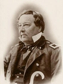
Captain Benjamin Bonneville

The map was originally engraved and printed by S. Stiles. Tribal lands are indicated for the following tribes (note that tribal names and the English spellings of them had not yet been established):
  • Wallawallah
  • Pends Orcilles
  • Skynses
  • Too-el-i-can
  • Nez Percés
  • Shoshoco
  • Flat Head
  • Upper Nez Percés
  • Bannack
  • Shoshonie
  • Eutaw

Materials

Archive Paper

Archive Paper

Premium fine art paper that provides accurate color reproduction with high-contrast, high-resolution print output and maximum image permanence. A high-quality print ready for framing.

More
  • Museum quality paper for high-quality fine art.
  • Ultra smooth, neutral white matte finish.
  • Heavy-weight 230 gsm, 9.5 mil thickness.
  • Printed with pigment inks for longer print life and enhanced fade resistance.
  • Pigment based Canon LUCIA inks provide smooth tones and rich colors in fine, precise detail.
USA map icon

Made In The USA

Our wall map products are designed and printed on demand by our small team in Seattle, WA using high quality materials and fine art giclee printing.
Purchase order icon

School Purchase Orders

We gladly accept purchase orders from schools and other government institutions. Learn more here
Icon of plane flying

Worldwide Shipping

International shipping options are available. Free shipping within the contiguous USA

Questions about Historical Map - Tribes of the Western United States - 1837?

World Maps Online is here to help you with all of your map needs. If you need help finding the right product, we're happy to answer questions you have. to send us a message on live chat.