The Confederate Army had difficulty throughout the war in supplying its field officers with adequate maps. The situation in the South was acute from the beginning of hostilities because of the lack of established government mapping agencies capable of preparing large-scale maps, and the inadequacy of reprinting facilities for producing them. The situation was further complicated by the almost total absence of surveying and drafting equipment, and the lack of trained military engineers and mapmakers to use the equipment that was available.
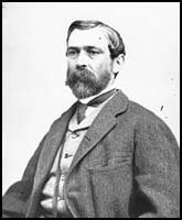
Detail of [Portrait of Lt. Gen. Richard Taylor, officer of the Confederate Army] |
Their ignorance of the land about them during the Seven Days' battles in 1862 was bitterly described by Gen. Richard Taylor. "The Confederate commanders," he wrote, "knew no more about the topography of the country than they did about Central Africa. Here was a limited district, the whole of it within a day's march of the city of Richmond, capital of Virginia and the Confederacy, almost the first spot on the continent occupied by the British race, the Chickahominy itself classic by legends of Captain John Smith and Pocahontas; and yet we were profoundly ignorant of the country, were without maps, sketches, or proper guides, and nearly as helpless as if we had been suddenly transferred to the banks of the Lualaba [Congo River]."
Confederate officers, of course, were not alone in their lack of adequate maps. During the Peninsula Campaign which culminated in the Seven Days' battles, Union Army commanders were also hard pressed to obtain reliable maps. Gen. George B. McClellan, commander of the Army of the Potomac, lamented that "Correct local maps were not to be found, and the country, though known in its general features, we found to be inaccurately described, in essential particulars, in the only maps and geographical memoirs or papers to which access could be had; erroneous courses to streams and roads were frequently given, and no dependence could be placed on the information thus derived. This difficulty has been found to exist with respect to most portions of the State of Virginia, through which my military operations have extended. Reconnoisances [sic], frequently under fire, proved the only trustworthy sources of information."
On assuming command of the Army of Northern Virginia from the wounded Joseph E. Johnston on June 1, 1862, Gen. Robert E. Lee, a former army engineer himself, took prompt action to improve the Confederate mapping situation. Five days after his appointment, Lee assigned Captain (later Major) Albert H. Campbell to head the Topographical Department. Within a few days, two or three field parties were organized and dispatched into the countryside around Richmond to collect the data for an accurate map of the environs of the Confederate capital. "The field work was mapped as fast as practicable," Campbell wrote, "but as the army soon changed its location, more immediate attention was given to other localities. Therefore, this map in question was dated 1862-3: it was not available as complete until the spring of 1863."
As quickly as possible, other survey parties were formed and sent into Virginia counties in which fighting was likely to occur. Based on the new information, Confederate engineers under the direction of Campbell and Maj. Gen. Jeremy F. Gilmer, Chief of Engineers, prepared detailed maps of most counties in eastern and central Virginia. The maps were drawn in ink on tracing linen and filed in the Topographical Department in Richmond.
Prepared most often on a scale of 1:80,000, with a few at 1:40,000, each county map generally indicated boundaries, villages, roads, railroads, relief (by hachures), mountain passes, woodland, drainage, fords, ferries, bridges, mills, houses, and names of residents. These maps today are sometimes referred to as the Gilmer-Campbell maps or the "Lost War Maps of the Confederates," the latter term being applied because their whereabouts was unknown until many years after the war. This was also the title of Albert Campbell's revealing article published in the January 1888 issue of Century Magazine.
Lt. C. S. Dwight's "Map of Albemarle County from Surveys and Reconnaissances" is typical of the maps made by Confederate engineers in Virginia. This well-executed map, drawn in ink on a sheet of tracing linen measuring 80 by 68 cm. was approved by Albert H. Campbell on June 15, 1864 (LC Civil War Maps no. 520a.8).
Introduction of Photography
Initially, when requests were received in the Topographical Department for maps of a particular area, a draftsman was assigned to make a tracing of the file copy. But, "So great was the demand for maps occasioned by frequent changes in the situation of the armies," Campbell noted, "that it became impossible by the usual method of tracings to supply them. I conceived the plan of doing this work by photography, though expert photographers pronounced it impracticable, in fact impossible . . . . Traced copies were prepared on common tracing-paper in very black India ink, and from these sharp negatives by sun-printing were obtained, and from these negatives copies were multiplied by exposure to the sun in frames made for the purpose. The several sections, properly toned, were pasted together in their order, and formed the general map, or such portions of it as were desired; it being the policy, as a matter of prudence against capture to furnish no one but the commanding general and corps commanders with the entire map of a given region." Jedediah Hotchkiss, Topographic Engineer with the Second Corps, Army of Northern Virginia, received from the Confederate Topographical Engineers Office the following formula and instructions for photocopying maps:
Formula of Sanxay used in copying maps in Topl.
Eng. Office, C.S.A. (from Sanxay)
Formula for Capt. Hotchkiss
Silver Bath
Nit. Silver 60 gr to 1 oz of water
Con Amonia 1 drop to the oz of water
float the paper on the Silver Solution then dry,
after printing
Wash the print about 15 minutes in fair water,
then immerse in Toning Bath
Bi Carb Soda Saturate Solution
Cloride Gold 15 gr to 1 oz water
nutralize [sic] gold solution with soda solution
(try with litmus paper)
Wash prints in fair water 15 minuets [sic] and then
immerse in Fixing Solution
Hypo Soda 1 lb to 1 gal water about 15 minuets [sic]
Wash in running water about 12 hours, dry and the
prints are finished.
Take the map to be copied and lay it on a glass in printing frame the back of map to the glass. Place the sencitised [sic] paper face to face on the map. Put the back in the frame and wedge it up tight. Expose it to the sun and make a dark print (that is very intense). Tone & fix, that will be the negative. Print in the same way from the negative to make the positive.
By 1864, therefore, the Confederate Topographical Department was capable of supplying field officers with photo-reproductions and thereby able to avoid making time-consuming tracings or costly lithographic prints. The resulting photocopies, although crude by today's standards, were quite legible and were frequently cut and mounted in sections on cloth to fold to a convenient size to fit an officer's pocket or saddle bag. Because of the lack of printing presses and paper, maps remained in relatively short supply. The manuscript and photo-reproduced copies that were available, however, were the equal in quality to the more numerous maps by Federal authorities. Campbell's "Map of the Vicinity of Richmond and Part of the Peninsula" is typical of the maps prepared by the Confederate engineers for the use of the field commanders. Prepared in 1864, the map was photographed, hand colored, sectioned, and mounted on cotton muslin to fold to 16 by 13 cm. (LC Civil War Maps no. 624-626).
All the maps used by the Federal and Confederate forces of course were not compiled and produced at headquarters in Washington or Richmond. On both sides, armies, corps, and divisions in the field had topographical engineers assigned to their staffs whose role was to gather information for the preparation of maps. Many significant reconnaissance maps were compiled in the field, detailed battlefield maps were prepared, and base maps supplied by headquarters were vastly improved as new information was collected.
Richard W. Stephenson, Civil War Maps
Source: Library of Congress