World Atlas History
Library of Congress Collection
The earliest atlases in the Library of Congress are associated with Claudius Ptolemy, an Alexandrian scholar who recorded and systematized classical Greek geographical knowledge during the second century. His Geographia was the first and most popular cartographic publication to be printed from movable type in the fifteenth and early sixteenth centuries. The Library of Congress holds forty-seven of the fifty-six known copies of Ptolemy's Geogaphia dating from 1475 to 1883, plus five variants and thirty-four duplicates, including rare copies of the 1482 Ulm edition, the 1490 Rome edition, the 1507 Rome edition with Johann Ruysch's world map incorporating the exploration of the New World by John Cabot, and the 1513 Strassburg edition with twenty supplemental maps including two new maps showing America.
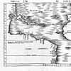
 The voyages of Christopher Columbus, John Cabot, and Amerigo Vespucci dramatically changed the world map. One of the earliest printed maps to incorporate this new world view was Johann Ruysch's map which is found in the 1507 reprinting of the 1490 Rome edition of Ptolemy's Geographia, both of which are represented in the division. It is believed that Ruysch, a native of Antwerp, accompanied Bristol seamen on a voyage to the great fishing banks off the coast of Newfoundland in about 1500.
 Martin Waldseemller's 1513 edition of Ptolemy was a landmark work that contributed to major advances in both Renaissance geography and map printing. Published by Johann Schott in Strassburg, it depicts for the first time in an atlas format the newly discovered continents of North and South America connected by a coastline.
A prized atlas treasure is a bound collection of maps assembled by Antoine Lafrry, a native of Burgundy who moved to Rome about 1540 and set up shop as an engraver and publisher. During this time the European map trade was dominated by cartographers in Rome and Venice who had perfected copperplate engraving for maps. Lafrry and other Italian publishers and dealers began to assemble these individual maps into bound folio volumes based on the interests of their customers. About seventy of these composite Italian atlases are extant today, each unique in its contents. In 1943, the Library of Congress of Congress purchased nine additional map sheets that were at one time part of a Lafrry atlas.
Abraham Ortelius revolutionized the map trade by publishing the first modern atlas. With the publication of his Theatrvm orbis terrarvm [Theater of the World] in Antwerp in 1570, the first book of maps uniform in size and design, the center of the European map trade shifted from Rome and Venice to Antwerp, the largest and most active port city in Europe. Engraved mainly by Franz Hogenberg and printed by Christoffel Plantijn, the first edition consists of seventy maps on fifty-three sheets assembled from the best available sources. Extremely popular in its day, numerous editions were issued from 1570 to 1724 in Latin, Dutch, French, German, English, and Italian. The Library of Congress of Congress's collection of Orteliana is one of the largest in the world. Of the eighty-two editions identifed, the Library of Congress possesses fifty-nine, a number of which are unique.
 Henricus Hondius's ornately decorated world map first appeared in the 1633 edition of the Atlas that was originally published in 1595 by the Flemish cartographer Gerard Mercator and subsequently published by Jodocus Hondius and his sons, Jodocus, Jr. and Henricus, and his son-in-law, Jan Jansson. The world is depicted in two hemispheres, which are bordered by the representation of the four elements of fire, air, water, and land as well as portraits of Julius Ceasar, the second-century (A.D.) geographer Claudius Ptolemy, and the atlas's first two publishers, Mercator and Hondius.
The name most associated with advancing cartography as a science during this formative period is the Flemish geographer Gerard Mercator who helped free geography from its Ptolemaic influence by his prodigious contributions in the production of globes, maps, map projections, and atlases. Through the generosity of Melville Eastham the division received copies of his magnum opus, Atlas sive cosmographic meditationes de fabrica mundi et fabricati figvra (Duisburg, 1595), and the first two parts of this atlas which were issued as separate publications prior to Mercator's death in 1594, Galliae tabule geographic(Duisburg, 1585) and Italiae, Sclavoni, et Grcitabule geographice (Duisburg, 1589). The Library of Congress has copies of these editions as well as representative copies of subsequent editions published by Jodocus Hondius, who purchased the plates in 1606, and by his son Henricus and Jan Jansson.
Other rare pre-1600 printed world atlases include Gerard de Jode's, Specvlvm orbis terrarvm [Mirror of the World] (Antwerp, 1578), one of twelve recorded copies; Christopher Saxton's An Atlas of England and Wales (London, 1579), the first atlas of any country, which is called "the Elizabethan atlas" because each map bears the coat of arms of Queen Elizabeth and Thomas Seckford, one of the Queen's Masters of Requests, who commissioned the maps; Corneille Wytfliet's Descriptionis Ptolemaic avgmentvm, siue Occidentis (Louvain, 1597), the first atlas devoted exclusively to the New World; Matthias Quad's Evropae totivs orbis terrarvm. (Cologne, 1592); and Maurice Bouguereau's Le thatre franois [Tours, 1594], one of nine known copies of the first national atlas of France.
The Golden Age of Dutch Cartography that was inaugurated by Ortelius and Mercator found its fullest expression during the seventeenth century with the production of monumental multivolume world atlases in Amsterdam by Joan Blaeu, Jan Jansson, Claes Janszoon Visscher, Abraham Goos, and Frederik de Wit. The division possesses excellent representative copies of all of these publishers, including Joan Blaeu's Le grand atlas (Amsterdam, 1667), a monumental twelve-volume French edition; Jansson's Novus Atlas (Amsterdam, 1658); and Joan Blaeu's Spanish edition of Atlas mayor, which he issued between 1659 and 1672. The Spanish edition is very rare because almost the whole edition was destroyed by fire in 1672 when the publishing house of Blaeu was burned. About twenty copies are known to exist in public libraries and private collections.
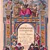 Title page from Pieter van den Keere's La Germanie Infrievre (Amsterdam, 1622), the first original atlas of the Netherlands published in folio size. Strong nationalistic overtones are evident in its iconography, which is typical of the elaborately decorated title pages found in Dutch atlases of the period.
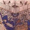
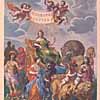 Frontispiece from Joan Blaeu's Le Grand Atlas, volume 1 (Amsterdam, 1667). Issued in twelve volumes, the French edition of Blaeu's great work is one of the largest and most elaborate atlases ever produced. It contains about six hundred exquisitely engraved and colored maps, plans, and drawings of all parts of the known world. The allegorical scene, showing the figure of Geography in a chariot drawn by two lions, is based on a painting by Peter Paul Rubens. The personification of the four continents is displayed by female gures associated with appropriate animals.
During the eighteenth century Dutch publishing houses continued the tradition of publishing voluminous atlases, often assembled from maps acquired from other rms. The Library of Congress's copy of Johannes Cvens and Cornelis Mortier's Atlas nouveau (Amsterdam, 1761?) includes 922 maps bound into nine volumes while its Reiner and Josua Ottens's Atlas maior (Amsterdam, 1641 1729) contains 835 maps by various cartographers, all beautifully hand colored. Housed in the Rare Book and Special Collections Division is a copy of the largest atlas ever published. Issued in sixty-six volumes by Pieter van der Aa between 1700 and 1729, the Galerie agrable du monde contains more than three thousand plates and maps. Of the 100 sets originally printed, only a few complete copies survive today.
»