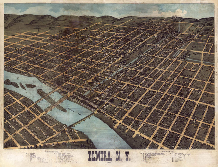
Historic Map - Elmira, NY - 1873
Description
Elmira, N.Y. : 1873 / drawn by H.H. Bailey.
Reproduction panoramic map of Elmira, New York, drawn by Howard Heston Bailey and published by Strobridge & Co. in 1873. Elmira is a city in Chemung County that was incorporated in 1864. Elmira was at the southern end of the Chemung Canal, and later it was linked with Corning through the Junction Canal. Elmira was also a railroad transportation center for New York's Southern Tier with the crossroads of the Erie Railroad and the New York Central.
During the American Civil War, Elmira was the site of Camp Rathbun near Foster's Pond, which was an army training camp and muster point. The camp took up 30 acres and in 1864 the camp's barracks were turned into a prisoner of war camp. Thousands of Confederate soldiers were confined here during the war. Many suffered due to malnutrition, bad sanitary conditions or exposure to severe weather. Barracks here were meant for 5,000, but 10,000 were brought in and made to live in tents on the banks of the cold river. Inmates nicknamed it "Hellmira" and by the end of the war tens of thousands died of dysentery, typhoid, pneumonia and a flooding of the Chemung River. After the war the camp buildings were demolished.
This bird's-eye view map from 1873 shows buildings and clearly labeled street names.
Features references to the following locations:
- Erie Depot
- Academy
- Court House
- Public Schools
- Elmira Female College
- Rathbun House, S. H. Wadsworth, Proprietor
- Hathaway House, F. Mitchell, Proprietor
- Delavan House, R. Hunt, Proprietor
- Frasier House, U. Bartholomew, Proprietor
- Elmira House, J. Davis, Proprietor
- Opera House
- Elmira Noble Manufacturing Co.
- William M. Jeffers, Planing Mill
- J. W. Bell, Planing Mill
- T. Briggs & Co., Brewers
- Reed & Cooper, Founders
- Morgan Dyer, Agricultural Foundry
- Andrews & Buge, Saw Manufacturing Co.
- J. G. Burritt, Elmira Agricultural Works
- W. R. Cooper, Elmira Cradle Manufactory
- Congregational Church
- First Baptist Church
- Free Will Baptist Church
- German Episcopal Church
- Trinity Episcopal Church
- Grace Episcopal Church
- Methodist Church
- Zion's Methodist Church-Colored
- Union Methodist Church-Colored
- Jewish Synagogue
- Hedding Methodist Church
- First Presbyterian Church
- Second Presbyterian Church
- Catholic Church
Materials
Archive Paper

Premium fine art paper that provides accurate color reproduction with high-contrast, high-resolution print output and maximum image permanence. A high-quality print ready for framing.
More
- Museum quality paper for high-quality fine art.
- Ultra smooth, neutral white matte finish.
- Heavy-weight 230 gsm, 9.5 mil thickness.
- Printed with pigment inks for longer print life and enhanced fade resistance.
- Pigment based Canon LUCIA inks provide smooth tones and rich colors in fine, precise detail.

Made In The USA

School Purchase Orders


