Spring Roller Pull-Down Maps
We have one of the largest selections of high quality educational pull-down maps mounted to spring rollers, choose Early Education Maps, World Classroom Maps, USA Classroom Maps, State Classroom Maps, Country Classroom Maps or Continent Maps for classrooms, maps are available for all grade levels and schools can order spring roller laminated maps using a purchase order. Education maps in this section are each mounted individually on pull-down spring rollers and are laminated or printed on durable non-tear vinyl. Maps feature a markable, washable surface and are ready to hang in the classroom using existing map mounting hardware or one of our map mounting hardware solutions. Our selection of spring roller maps are available with political cartography (international boundaries) or physical cartography (topography, natural features) in a wide variety of options that meet every grade level from kindergarten and elementary to high school and college. Individual maps are available for the World, United States, continents, and select countries. Below you will find all the maps you will ever need for teaching your school geography or social studies curriculum.

World Classroom Maps
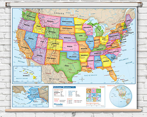
United States Classroom Maps

US States Spring Roller Maps

Canada Classroom Maps

Continents Spring Roller Classroom Maps
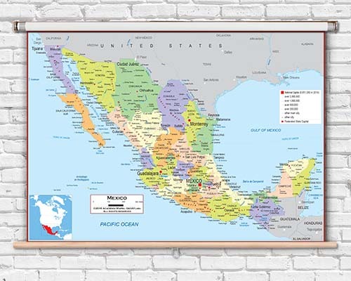
Country Roller Maps

Beginner and Starter Maps for Early Learning
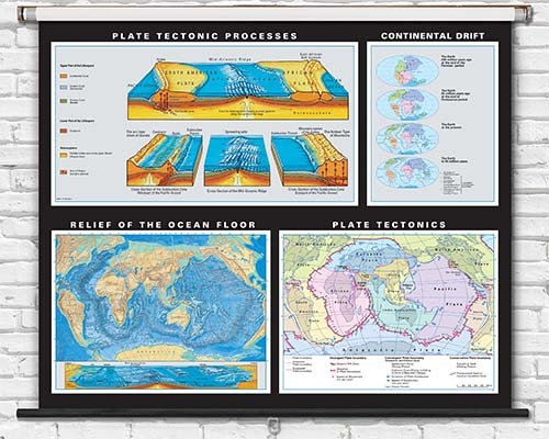
Earth - Environmental Science
Spring roller maps are designed with a locking mechanism that holds the map open at full extension. When you pull the map down, it stays in place until you give a slight tug to release the spring-loaded retraction. This ensures the map remains visible throughout an entire lesson without drifting upward.
Yes. Spring roller maps arrive fully assembled with the map already mounted on the roller mechanism. The roller includes mounting brackets for wall or ceiling installation. You simply attach the brackets to the wall and hang the assembled roller unit.
Laminated spring roller maps are compatible with dry-erase markers. Teachers can annotate, circle locations, and trace routes during lessons and wipe clean afterward. Non-laminated spring roller maps are for display only. Lamination is indicated in the product specifications.
Laminated spring roller maps are built for years of institutional use. The spring mechanism maintains tension through thousands of cycles, and the laminated surface resists tearing and marker wear. Many schools use the same spring roller maps for 5 to 10 years of continuous service.
The Spring Roller Pull-Down Maps collection includes world maps, United States maps, individual US state maps, continent maps, and country maps. Both political and physical styles are available across multiple grade levels and complexity levels.
Installation requires a drill, appropriate wall anchors or screws (for the mounting brackets), and a level to ensure straight alignment. Most school maintenance staff can complete the installation with basic tools. Mounting brackets are included with the roller or available separately.
Quality spring roller mechanisms are designed to maintain consistent tension over many years and thousands of cycles. If tension does diminish over extended use, the roller unit can typically be re-tensioned or the roller mechanism replaced without discarding the map itself.
Yes. Individual state spring roller maps are available for all 50 US states. Each state map shows detailed political boundaries, cities, geographic features, and key points of interest. State maps are popular for social studies and state history curriculum.
Yes. Spring roller mounting brackets can be installed on either the wall or the ceiling depending on your classroom layout. Ceiling mounting is useful when wall space is limited or when you want the map to hang in front of a whiteboard during use.
Yes. School purchase orders are accepted and processed immediately. Orders are invoiced under net 30 terms. Submit a signed purchase order to [email protected]. Quantity orders over $2,000 qualify for a 10% bulk discount.