5 interactive mapping tools that are changing education
Interactive mapping tools have revolutionized the way geography, history, and environmental studies are taught in schools. Some still prefer the look and feel of traditional world wall maps. For others, the solution has got to be a digital one. These digital tools offer dynamic, engaging ways to explore the world and understand complex geographical concepts. Below is an in-depth look at five interactive mapping tools that are making significant impacts in educational settings.
1. GOOGLE EARTH (EARTH.GOOGLE.COM)
Google Earth is a virtual globe, map, and geographical information program that presents a 3D representation of Earth based on satellite imagery.
- How it's used: Teachers use Google Earth to take students on virtual field trips to any place around the globe. It's used to explore geographical landscapes, understand environmental changes, and study various cultures and histories.
- Something to Try: Go on a virtual tour of the Seven Wonders of the World. Start by searching for "Great Wall of China" in Google Earth, and then visit each wonder in turn. Explore the 3D models and read the information provided to learn about the history and significance of each site.

2. ARCGIS ONLINE (WWW.ARCGIS.COM)
ArcGIS Online by Esri is a cloud-based mapping and analysis solution.
- How it's used: It allows students to create, analyze, and share interactive maps. It's often used in more advanced geography and social studies classes to teach about spatial analysis and data interpretation.
- Something to Try: Create a map showing your local area's historical landmarks. Use the ArcGIS map creation tool to plot points on the map where these landmarks are located. Add descriptions and photos if available. This can help you understand the historical context of your local area.

3. STORYMAPJS (STORYMAP.KNIGHTLAB.COM)
StoryMapJS is a free tool to help you tell stories on the web that highlight the locations of a series of events.
- How it's used: Teachers use it for projects where students can build narratives around historical events, literature settings, or scientific discoveries, embedding maps into their storytelling.
- Something to Try: Create a StoryMap of a famous historical event, like the voyage of Christopher Columbus. Plot key locations on the map and add descriptions, images, or videos to each point to narrate the journey step by step.

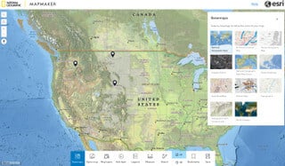
4. NATIONAL GEOGRAPHIC MAPMAKER INTERACTIVE (MAPMAKER.NATIONALGEOGRAPHIC.ORG)
MapMaker Interactive by National Geographic is a tool designed to allow users to explore and customize maps for educational purposes.
- How it's used: This tool is great for younger students to explore different layers of maps, such as political boundaries, physical terrain, climate, and population. It's used to teach about the interconnectedness of the world.
- Something to Try: Customize a map showing the different types of climates around the world. Use the layer tool to add climate data, and then explore how climate varies in different regions. This is a great way to visualize and understand global climate patterns.

5. GAPMINDER TOOLS (WWW.GAPMINDER.ORG/TOOLS)
Gapminder Tools offers a range of resources for understanding complex global trends.
- How it's used: Teachers use Gapminder to illustrate complex statistical data in a visual format. It's excellent for lessons on global development, economics, and population growth.
- Something to Try: Use Gapminder to explore global health trends. Select a dataset, such as life expectancy or income, and watch how these indicators have changed over time across different countries. This can provide insights into global development trends and the factors that influence them.

The integration of interactive mapping tools into educational settings is more than just a technological advancement; it's a gateway to a deeper, more engaging way of learning. These tools provide students and educators alike with dynamic ways to explore our world and its complex systems.
By incorporating these digital resources into their curriculum, educators are not only making learning more interactive and enjoyable but are also equipping students with essential skills in spatial thinking, data interpretation, and global awareness. Whether it's through creating story-driven maps with StoryMapJS, analyzing climate patterns with National Geographic's MapMaker Interactive, or delving into the intricacies of local history with ArcGIS Online, these tools offer endless possibilities for exploration and discovery.
In embracing these innovative mapping tools, we open up a world of learning opportunities that extend far beyond the traditional classroom walls. They invite us to explore, understand, and connect with our world in ways that were previously unimaginable, making education a truly boundless adventure.