Bird’s-eye View of Wiscasset, Lincoln County, Maine, 1878. Drawn by Albert Ruger. The name Wiscasset, given this town by the Abenaki tribe, translates to "coming our from the harbor but you don't see where". First settled in 1663, it was abandoned during the King Philip's War (1675-78). The community was resettled in 1730, taking the name Pownalborough in 1760, after Colonial Governor Thomas Pownall. Following the American Revolutionary War, it reverted back to the Abenaki name, Wiscasset.
Following is a brief "History of Wiscasset, Maine" from "A Gazetteer of the State of Maine" by Geo. J. Varney, published in 1886.
"Wiscasset is situated on the Sheepscot River, in the south-eastern part of Lincoln County. Wiscasset Bay, an enlargement of Sheepscot River, occupies about one-third of the eastern side of the town, and is one on the best harbors on our eastern coast, being thoroughly protected, capacious, deep, and open even when Boston harbor is closed as far as the Castle. A United States Surveying Commission, in 1813, strongly recommended to the navy department the propriety of establishing a navy yard in Wiscasset. One hundred vessels of the largest size can anchor here at once in from 12 ro 20 fathoms of water. A huge bridge has been thrown across the river to Edgecomb, directly above the harbor, which has a draw of 34 feet, through which vessels of 1000 tons pass without difficulty. The surface of the town is variable altitude, having many gorges, through which flow brooks, or inlets from the sea. The usual variety of forest trees are found in various parts of the town, some of them of old growth; and old and young are often in naturally picturesque arrangement. The town is about 10 miles in length from north to south, its southern extremity resting on Minsweag Bay. It is bounded on the west by Woolwich and Dresden, on the north by Alna; the island town of Westport, in the river, and beyond, Edgecomb, with the southern part of Newcastle, on the east. A stream, the site of early settlement, crosses the midst of the town to the Sheepscot.
On Monsweag Stream, which forms the dividing line between Wiscasset and Woolwich, are eight water-powers, all of which have been in time past improved, but all, except one, have now been washed away or burned, or are in ruins. Ona tidal cove, in the north-eastern part of town, are the picturesque ruins of a mill and dam. Clark's Point and Hill beyond are prominent objects. The view from the Hill is extensive and beautiful, embracing numerous hills, forests, dales foaming streams and shining arms of the sea. The hill was formerly a station of the United States coast survey. South of the village is a picturesque cemetery, and below it a grassy glen succeeded by a lofty hill called Cushman's Mountain, that looks down upon the river and Monsweag Bay. Away to south-west of this hill is Jewonke Neck, full of varied, picturesque scenery, including both sea and shore. The drives either up or down the river, or over the Monsweag road to Woolwich are very pleasing. The village has several fine residences,- one in full view from the cars as they approach from the west being particularly striking and elegant. The village park, shaded by old elms and surrounded by the Congrgational Church, the courthouse and pleasant residences, is an attractive spot. The Episcopal Church and the rectory adjoining, afford a contrast of old and new styles of architecture.
The principal mills in operation are near the village on the south side. They are run by steam-power; and vessels of large size load at the whaves beside them. Of these, the first, on Hobson's Island, produces lumber and box shooks. In connection with it is a grist-mill. The second and more distant mill, is situated on Birch Point, and is devoted mainly to long and short lumber. The principal other manufactures are sails and bricks.
The first settlement of Wiscasset was made by George Davis, who is said to have lived about half a mile north of the point where the jail now stands. He purchased of the Indians a tract of several hundred acres, embracing within its limits the present village of Wiscasset. During the summer of the year mentioned, he with his assistants erected several buildings, and made improvements of various kinds, as well as encouraged the location of other settlers. On the breaking out of King Philip's War, in 1675, the people were obliged to flee from their homes; and for nearly sixty years afterward the town was entirely depopulated. Robert Hooper came in with his family of four persons in 1730, and was thus the pioneer of the re-settlement. He erected his house by the side of a large rock on the eastern side of where Water street now runs. He had brough with him a small stock of cattle, and a number of fruit trees. In 1734, Michael Seavey, Robert Groves, Sheribiah Lambert, and a man by the name of Foye came in from Rye, N.H. Josiah Bradbury, Nathaniel Rundlett, Richard and Benjamin Holbrook, and Colonel Kingsbury arrived about the same time. A few years later, John Young and Messrs. Taylor, Boynton and Chapman settled on Cross River about two miles south of Wiscasset Point, the site of the village. Numbers increased yearly from this time, until in 1740 there was a plantation of 30 families, numbering 150 persons.
On ahill south-west of the village was erected, in 1743, a fortification, some relics of which are yet to be seen. It is related that in the latter part of Sept, 1744, a party of 20 Indians arrived before it, in a dense fog, for the purpose of an attack. The only persons in at the time were two women and a girl, the men being at work in the fields at some distance. A little clearing away of the mist revealed to the womwn their approaching enemies. They quickly barricaded the doors; and disguishing their voices, called to a number of imaginery persons to put the place in a state of defense. The Indians, believing that there was a large force within the fort, became alarmed and abandoned their design. In the summer of 1745, a man returning from the Seavey farm to the garrison, and while yet about 60 rods distant, from it was shot by an Indian concealed in the forest. Soon after this, two block-houses were built, one on what is now called Fort Hill, the other on Seavey's Hill. This settlement was included, together with Alna, Dresden and Perkins, in the town of Pownalborough, and incorporated in 1760, the name being adopted in honor of Thomas Pownal,-at this date, governor of Massachusetts. It was incorporated under its present name in 1802.
During the Revolution, the British sloop-of-war Rainbow came up the river, and, anchoring in the harbor, laid the town under contribution for supplies. The inhabitants were threatened with the halter and the town with destruction unless complied with the requisitions; and having no defenses, they were obliged to yield up their provisions.
Immediately on the conclusion of peace, an extensive business greq up between Wiscasset and foreign parts; and it was also the chief mart of trade for the home region. There were her palmy days. Most of her inhabitants were more or less interested in navigation, and her ships were found on every sea. But the embargoof 1807 on shipping was laid at an unfortunate time, and dealt a destructive blow to her business and prosperity; and the war of 1812 completed the mischief, so that the town has never to this day retrieved its fallen ofrtunes. Should the railroad projected to connect Wiscasset with Quebec by way of Point Levi be built, the commodions harbor and land-locked waters of the Sheepscot must became an entrepot between England and the Canadas, by a shorter route than would be afforded by any other port. Judges Bailey, Orchard Cook, Hons. J. D. McCrate and Abiel Wood, of this town, have been representatives in Congress; and Hon,. Samuel E. Smith, another citizen, was for three years govenor of Maine. Judge Lee, a citizen of the Revolutionary period, and Rev. Dr. Packard, a worthy Congregational minister of the same day, are the subjects of pleasing reminiscence,
Wiscasset has, since the Revolution, been the seat of a custom house for the river and contiguous portions of the sea. The number of vessels now owned in the district is 161, having a tonnage of 9,894 tons. The products of fisheries in this district in 1879 was $366,445. The Knox and Lincoln railroad passes through the town, having a station at the village, 10 miles from Bath. As Pownalborough and Wiscasset, this has been the shire town of the county since 1794.
The Episcopalians, Congregationalists and Methodists each have a church in the village. Wiscasset has seven public schoolhouses; and these, with other school property, are valued at $4,250. The village has a system of graded schools. The valuation of estates in 1870 was $689,554. In 1880 it was $319,773. The population in 1870 was 1,977. In 1880 it was 1,832."
Features numbered & lettered references to the following locations:
Court House. Jail. U. S. Custom House & Post Office. High School. Primary School. R. R. Depot. Location of Old County Jail of 1800, where British prisoners were confined. Episcopal Church. Congregational Church. Methodist Church. Ancient Cemetery. Evergreen Cemetery. Green Lawn Cemetery. Sweet Auburn Cemetery. Hilton House, W. G. Hubbard, Prop.. Belle Haven Hotel. Booth Bay Steamer Landing. Fire Engine Houses. Isaac T. Hobson's Steam Saw, Grist, & Lumber Mills. R. H> Tucker's Brick Yard. Cunningham & Bailey's Marble Works. C. H. Ames' Wagon & Carriage Shops. Powder House.
We use top-notch materials printed on demand using the Giclée printing method, so you get amazing detail and bright colors every time.
Archival Paper
Premium fine art paper that provides accurate color reproduction with high-contrast, high-resolution print output and maximum image permanence. A high-quality Giclée print ready for framing.
Museum quality paper for high-quality fine art.
Ultra smooth, neutral white matte finish.
Heavy-weight 230 gsm, 9.5 mil thickness.
Printed with pigment inks for longer print life and enhanced fade resistance.
Pigment based Canon LUCIA inks provide smooth tones and rich colors in fine, precise detail.
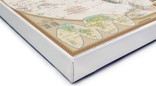
Canvas Gallery Wrap
A high quality canvas giclee print is hand stretched over a sturdy wood frame. Printed on demand and handcrafted in Seattle, WA. The canvas gallery wrap serves as a stunning piece of art ready to hang on your wall.
Premium 19 mil canvas material.
Pigment based Canon LUCIA inks provide smooth tones and rich colors in fine, precise detail.
High quality giclee fine art print with a lightfastness rating of over 100 years.
Durable canvas mounted to a 1.25" deep wood frame.
Ready to hang with included easy-to-use hanging kit.
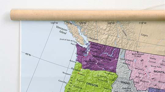
Canvas on Wood Rails
A canvas giclee print that is mounted to wood hanging rails placed along the top and bottom of the map. Rail mounted maps are ready to hang via the attached hanging cord. Solid wood rails have a natural finish.
Premium 19 mil canvas material.
Wood rails are 1 1/8" wide, round front.
USA sourced solid maple wood.
High quality giclee fine art print with a lightfastness rating of over 100 years.
Pigment based Canon LUCIA inks provide smooth tones and rich colors in fine, precise detail.
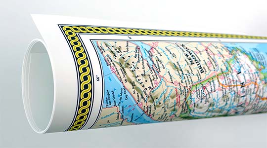
Luster Photo Paper
A premium semi-gloss photo paper with a subtle texture that produces a vivid, richly detailed print. This material results in an exquisitely detailed giclee print of substantially higher quality than a standard poster.
Printed on 10 mil premium luster photo paper resulting in a brilliant, colorful image with a vivid life-like quality.
Pigment based Canon LUCIA inks provide smooth tones and rich colors in fine, precise detail.
Inks have a lightfastness rating of over 100 years, guaranteeing minimal noticeable fading over a very long period of time.
Printed using very high resolution source files.
Giclee printing is superior to traditional lithography in a number of ways: colors are brighter, lasts longer, and is a higher resolution.
Framed Print
Our gallery quality frames are made of solid wood and feature optical-grade acrylic. Each framed map is printed on premium archival matte fine art paper.
Printed on thick, luxurious acid-free fine art paper & dry-mounted to foam board.
Pigment inks ensure a vivid print with amazing colors and excellent fade resistance.
Solid wood frame in 5 finishes has a 7/8" face & 1.25" depth.
Kraft paper protective backing & hanging wire installed.
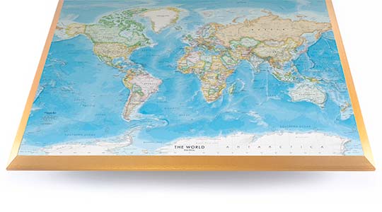
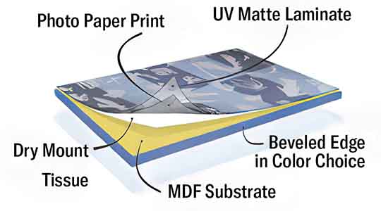
Plaque Mount
A museum grade display featuring high-resolution printing on premium photo paper, mounted on a durable wood plaque with a protective matte laminate. Surface can be cleaned with glass cleaner.
A premium photo print is dry-mounted to onto wood substrate (MDF).
Features a highly durable laminated surface that is scratch-resistant, water-resistant and fade-resistant.
Lamination is a non-glare matte finsh that can be wiped clean with a damp cloth or glass cleaner.
Mounted to 3/8" thick MDF wood panel with a 3/8" wide beveled edge available in premium foil color options.
Keyhole slot with velvet feet on the corners for easy wall mounting. Hanging hardware included.
Plaque Mounting Process
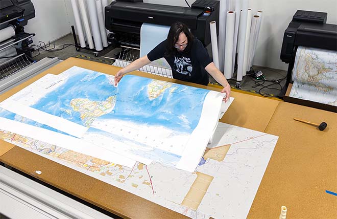
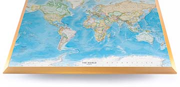
Gallery quality map prints made in the USA
We specialize in producing high-quality, detailed maps using advanced printing technologies and premium materials. Stringent quality control and ultra-high-resolution printing guarantee absolute clarity and precise detail at any size. Whether it's a smaller wall map print or a gigantic wallpaper map mural, no print will appear blurry or pixelated. You can expect every detail on the map to be sharp and clear.
Finely Crafted Cartographic Works of Art
Many of the maps we provide are created by our small team of cartographers under the name Academia Maps.
Museum Quality Materials
We source the best materials for our map prints and wallpaper maps. Premium archival inks guarantee rich vibrant colors with excellent fade resistance.
USA Print Production
We are a small business located in Seattle, WA that has been printing maps for over 15 years. Each map is printed on-demand using high-end fine art printers.
Shipping Costs
Free Ground Shipping within the contiguous United States and a flat rate of $20.00 to AK and HI.
Canada via UPS Standard is $40.00 USD.
Worldwide Shipping is available and shipping costs will be calculated at checkout.
Shipping Times
Most items are made to order and ship from our Seattle, WA facility. Typical production lead times are listed below. Shipping transit time is 2-5 business days depending on the delivery location. If you need your map by a certain deadline please contact us for expedited options.
Archival Paper, Laminated Maps, and Peel & Stick - 5-7 business days
Wood Rail Mounting - 3-4 weeks
Canvas Gallery Wraps & Framed Maps - 3-5 business days
Push Pin Maps - 3-5 business days
Spring Roller Maps - Varies, see product description
Wallpaper Map Murals - 7-10 business days
Returns
If you are unhappy with your order for any reason you can return it within 30 days of the delivery date. Customized items are non-returnable.
Yes, we can produce a majority of the map titles found on our website in a custom size. If you would like to request a custom size, take note of the map title and item#, then follow one of the links below to make your request. We will follow up with a link to checkout.
(for rolled or mounted prints)
(for larger peel & stick / wallpaper maps)
All of our maps are currently labeled as "Gulf of Mexico". Since our map products are printed to order, we can offer the alternate "Gulf of America" labeling by request.
If you would like your map to be labeled Gulf of America instead of Gulf of Mexico, simply request this in the comments section at checkout, and we will update the map.
We accept purchase orders from schools and government entities. You can e-mail a copy of your PO to contact@worldmapsonline.com.
View more information and download our W-9.
No problem, send a screenshot or PDF of your shopping cart to contact@worldmapsonline.com and will promptly follow up with a quotation.
Our products are printed on demand and have the following production lead times:
Archival Paper, Laminated Maps, and Peel & Stick - 5-7 business days
Wood Rail Mounting - 3-4 weeks
Canvas Gallery Wraps & Framed Maps - 3-5 business days
Spring Roller Maps - Varies, see product description
Shipping transit time is 2-5 business days and will vary depending on your location. Most products ship from Seattle, WA.
Many of the maps found on our website can be customized, including adding a personalized title/legend or company logo, modifying the color scheme, change text labels, adding points of interest, and placing GIS data on the map.
If the order is shipping outside of Washington state, sales tax may not apply. We collect sales taxes per state and local laws. Sales tax is calculated at checkout based on the delivery address.
We can ship to nearly any country. The shipping cost is determined for Canada and most European countries at checkout. If you find that shipping is unavailable to your country when checking out then please contact us with a list of the products you would like to order as well as size and material options.
We can produce a custom map for any location in the world. Whether you are looking for a detailed city street map or high resolution satellite imagery of a remote area, we have you covered.
Because maps aren't just décor—they're personal stories, travel memories, and future adventures waiting to happen. SHOP BESTSELLING MAPS
🎁 Meaningful: Track travels, spark memories, plan new experiences.
🎄 Perfect for gifts: Unique, educational, and visually stunning.
🏠 Fits any home décor: Modern, vintage, minimalist & artistic styles available.
✏️ Personalizable: Add names, family titles, travel quotes (push-pin maps).
✈️ Great for travelers, students, families, teachers & offices.
Wall Maps Material Info
We use museum grade papers and canvas along with high quality solid wood mounting options.
Made in the USA
Archival Paper
Premium Giclée fine art print on thick acid-free paper with a matte finish. Features rich, vibrant colors with precise detail.
Luster Photo Paper
Giclée fine art print on semi-gloss photo paper. A richly detailed print with vivid colors.
Canvas on Wood Rails
High-quality giclée print on artist-grade canvas mounted to natural finish solid wood hanging rails placed along the top and bottom of the canvas. Hanging cord at top.
Canvas Gallery Wrap
High-quality giclée print on artist-grade canvas. Wrapped around a sturdy wooden frame, this print is perfect for adding depth and texture to any space.
Framed Map Print
Printed on high-grade fine art paper and mounted in a solid wood frame available in 5 finishes. The print is protected behind optical-grade clear acrylic.
Plaque Mount
A high resolution photo print dry-mounted to wood and sealed with a durable matte laminate. A sleek frameless look with a beveled edge that is available in multiple color finishes.
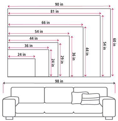
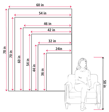
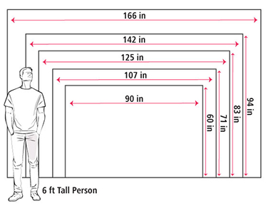
Size Guide
These mockups are to be used as a general visual aid to assist you in choosing a size. The measurements may not reflect the exact sizes of the product you are viewing. It is always best practice to measure your wall space prior to ordering.
Our wall maps and wallpaper map murals are handcrafted by our small team in Seattle, WA.
School Purchase Orders
We accept purchase orders from schools and other government institutions. Learn more here.
High Quality Materials
Maps are printed on premium fine art papers, canvas, and durable wallcovering materials using archival inks.
Stunning Cartography
Original and up-to-date maps designed by our cartographic team at Academia Maps include a range of high quality maps for geographic exploration, home decor, and classroom learning.