History of Railroad Maps
Surveying and mapping activities flourished in the United States as people began moving inland over the inadequately mapped continent. The settlement of the frontier, the development of agriculture, and the exploitation of natural resources generated a demand for new ways to move people and goods from one place to another. Privately owned toll or turnpike roads were followed first by steamships on the navigable rivers and by the construction of canals and then in the 1830s by the introduction of railroads for steam-powered trains.
The Beginnings of American Railroads and Mapping
Railways were introduced in England in the seventeenth century as a way to reduce friction in moving heavily loaded wheeled vehicles. The first North American "gravity road," as it was called, was erected in 1764 for military purposes at the Niagara portage in Lewiston, New York. The builder was Capt. John Montressor, a British engineer known to students of historical cartography as a mapmaker.
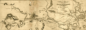 Right Half of James Hayward's 1828 plan of a survey for the proposed Boston and Providence Railway. This is the earliest topographic strip map in the Library showing a railroad survey. These lines were originally intended for horse drawn trains. |
The earliest survey map in the United States that shows a commercial "tramroad" was drawn in Pennsylvania in October 1809 by John Thomson and was entitled "Draft Exhibiting . . . the Railroad as Contemplated by Thomas Leiper Esq. From His Stone Saw-Mill and Quarries on Crum Creek to His Landing on Ridley Creek." Thomas Leiper was a wealthy Philadelphia tobacconist and friend of Thomas Jefferson, who owned stone quarries near Chester. Using his survey map, Thomson helped Reading Howell, the project engineer and a well-known mapmaker, construct the first practical wooden tracks for a tramroad. Thomson was a notable land surveyor who earlier had worked with the Holland Land Company. He was the father of the famous civil engineer and longtime president of the Pennsylvania Railroad, John Edgar Thomson, who was himself a mapmaker. In 1873 the younger Thomson donated his father's 1809 map to the Delaware County Institute of Science to substantiate the claim that the map and Leiper's railroad were the first such work in North America.
In 1826 a commercial tramroad was surveyed and constructed at Quincy, Massachusetts, by Gridley Bryant, with the machinery for it developed by Solomon Willard. It used horsepower to haul granite needed for building the Bunker Hill Monument from the quarries at Quincy, four miles to the wharf on the Neponset River.
These early uses of railways gave little hint that a revolution in methods of transportation was underway. James Watt's improvements in the steam engine were adapted by John Fitch in 1787 to propel a ship on the Delaware River, and by James Rumsey in the same year on the Potomac River. Fitch, an American inventor and surveyor, had published his "Map of the Northwest" two years earlier to finance the building of a commercial steamboat. With Robert Fulton's Clermont and a boat built by John Stevens, the use of steam power for vessels became firmly established. Railroads and steam propulsion developed separately, and it was not until the one system adopted the technology of the other that railroads began to flourish.
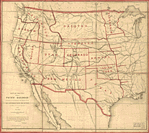 First edition of G.K. Warren's "hurried compilation," indicating the routes of the Pacific railroad surveys. The map was appended to the U.S. War Department's official report to Congress. (1857) |
John Stevens is considered to be the father of American railroads. In 1826 Stevens demonstrated the feasibility of steam locomotion on a circular experimental track constructed on his estate in Hoboken, New Jersey, three years before George Stephenson perfected a practical steam locomotive in England. The first railroad charter in North America was granted to Stevens in 1815. Grants to others followed, and work soon began on the first operational railroads.
Surveying, mapping, and construction started on the Baltimore and Ohio in 1830, and fourteen miles of track were opened before the year ended. This roadbed was extended in 1831 to Frederick, Maryland, and, in 1832, to Point of Rocks. Until 1831, when a locomotive of American manufacture was placed in service, the B & O relied upon horsepower.
Soon joining the B & O as operating lines were the Mohawk and Hudson, opened in September 1830, the Saratoga, opened in July 1832, and the South Carolina Canal and Rail Road Company, whose 136 miles of track, completed to Hamburg, constituted, in 1833, the longest steam railroad in the world. The Columbia Railroad of Pennsylvania, completed in 1834, and the Boston and Providence, completed in June 1835, were other early lines. Surveys for, and construction of, tracks for these and other pioneer railroads not only created demands for special mapping but also induced mapmakers to show the progress of surveys and completed lines on general maps and on maps in "travelers guides".
Planning and construction of railroads in the United States progressed rapidly and haphazardly, without direction or supervision from the states that granted charters to construct them. Before 1840 most surveys were made for short passenger lines which proved to be financially unprofitable. Because steam-powered railroads had stiff competition from canal companies, many partially completed lines were abandoned. It was not until the Boston and Lowell Railroad diverted traffic from the Middlesex Canal that the success of the new mode of transportation was assured. The industrial and commercial depression and the panic of 1837 slowed railroad construction. Interest was revived, however, with completion of the Western Railroad of Massachusetts in 1843. This line conclusively demonstrated the feasibility of transporting agricultural products and other commodities by rail for long distances at low cost.
Early railroad surveys and construction were financed by private investors. Before the 1850 land grant to the Illinois Central Railroad, indirect federal subsidies were provided by the federal government in the form of route surveys made by army engineers. In the 1824 General Survey Bill to establish works of internal improvements, railroads were not specifically mentioned. Part of the appropriation under this act for the succeeding year, however, was used for "Examinations and surveys to ascertain the practicability of uniting the head-waters of the Kanawha with the James river and the Roanoke river, by Canals or Rail-Roads."
In his Congressional History of Railways, Louis H. Haney credits these surveys as being the first to receive federal aid. He notes that such grants to states and corporations for railway surveys became routine before the act was repealed in 1838.
The earliest printed map in the collections of the Library of Congress based on government surveys conducted for a state-owned railroad is "Map of the Country Embracing the Various Routes Surveyed for the Western & Atlantic Rail Road of Georgia, 1837". The surveys were made under the direction of Lt. Col. Stephen H. Long, chief engineer, who ten years earlier had surveyed the routes for the Baltimore and OhioWork on the 138-mile Georgia route from Atlanta to Chattanooga started in 1841, and by 1850 the line was open to traffic. Its strategic location made it a key supply route for the Confederacy. It was on this line that the famous "Andrews Raid" of April 1862 occurred when Union soldiers disguised as railroad employees captured the locomotive known as the General.
The Transcontinental Railroad
The possibility of railroads connecting the Atlantic and Pacific coasts was discussed in the Congress even before the treaty with England which settled the question of the Oregon boundary in 1846. Chief promoter of a transcontinental railroad was Asa Whitney, a New York merchant active in the China trade who was obsessed with the idea of a railroad to the Pacific. In January 1845 he petitioned Congress for a charter and grant of a sixty-mile strip through the public domain to help finance construction.
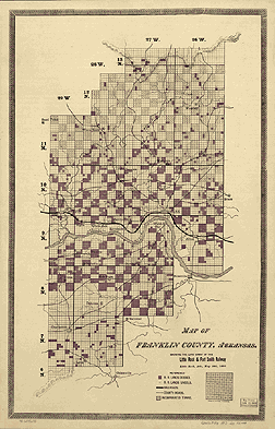 A large-scale grant map dated 1893, showing the alternate sections of public land granted to the Little Rock & Fort Smith Railway. Such maps were used by land speculators to advertise railroad lands for sale to the public. |
Whitney suggested the use of Irish and German immigrant labor, which was in great abundance at the time. Wages were to be paid in land, thus ensuring that there would be settlers along the route to supply produce to and become patrons of the completed line. The failure of Congress to act on Whitney's proposal was mainly due to the vigorous opposition of Sen. Thomas Hart Benton of Missouri, who favored a western route originating at St. Louis.
In 1849 Whitney published a booklet to promote his scheme entitled Project for a Railroad to the Pacific. It was accompanied by an outline map of North America which shows the route of his railroad from Prairie du Chien, Wisconsin, across the Rocky Mountains north of South Pass. An alternate route to the south of the pass joined the main line at the Salmon River and continued to Puget Sound. Proposed lines also extended from St. Louis to San Francisco and from Independence, Missouri, to New Mexico and the Arkansas River. This is one of the earliest promotional maps submitted to Congress and was, according to its author, conceived as early as 1830.
Although Congress failed to sanction his plan, Whitney made the Pacific railroad one of the great public issues of the day. The acquisition of California following the Mexican War opened the way for other routes to the coast. The discovery of gold, the settlement of the frontier, and the success of the eastern railroads increased interest in building a railroad to the Pacific.
Railroads were also needed in the West to provide better postal service, as had been developed in the East, by designating railroad lines "post roads" in 1838. Strengthened by other proposals such as those of Hartwell Carver in 1849 and of Edwin F. Johnson in 1853, such leading statesmen as John C. Calhoun, Stephen A. Douglas, and Jefferson Davis declared their support for linking the country by rails. The lawmakers, however, could not agree on an eastern terminus, and they did not see the merits of the several routes west. To resolve the debate, money was appropriated in 1853 for the Army Topographic Corps "to ascertain the most practicable and economical route for a railroad from the Mississippi River to the Pacific Ocean."
Under the provisions of the Army Appropriation Act of March 1853, Secretary of War Jefferson Davis was directed to survey possible routes to the Pacific. Four east to west routes, roughly following specific parallels, were to be surveyed by parties under the supervision of the Topographical Corps. The most northerly survey, between the 47th and 49th parallels, was under the direction of Isaac Ingalls Stevens, governor of Washington Territory. This route closely approximated that proposed by Asa Whitney.
The ill-fated party under Capt. John W. Gunnison was to explore the route along the 38th and 39th parallels, or the Cochetopoa Pass route, which was advocated by Missouri Senator Thomas Hart Benton. After Gunnison's death at the hands of hostile Indians, Lt. Edward G. Beckwith continued the survey along the 41st parallel. Capt. Amiel W. Whipple, assistant astronomer of the Mexican Boundary Survey, and Lt. Joseph Christmas Ives surveyed the route along the 35th parallel westward to southern California. This line was favored by Jefferson Davis and was essentially the route traversed by Josiah Gregg in 1839 and later surveyed by Col. John J. Abert. The most southerly survey, which followed the 32d parallel, was surveyed by Lt. John G. Parke from California along the Gila River to the Pima villages and the Rio Grande. Capt. John Pope mapped the eastern portion of the route from Dona Ana, New Mexico, to the Red River.
A fifth survey, following a north-south orientation, was conducted under the direction of Lt. Robert S. Williamson. This party reconducted topographical surveys to locate passes through the Sierra Nevadas and the Coast Range in California in order to determine a route that would connect California, Oregon, and Washington were made under the direction of Lt. Robert S. Williamson.
These surveys showed that a railroad could follow any one of the routes, and that the 32nd parallel route was the least expensive. The Southern Pacific Railroad was subsequently built along this parallel. The southern routes were objectionable to northern politicians and the northern routes were objectionable to the southern politicians, but the surveys could not, of course, resolve these sectional issues.
While sectional issues and disagreements were debated in the late 1850s, no decision was forthcoming from Congress on the Pacific railroad question. Theodore D. Judah, the engineer of the Sacramento Valley Railroad, became obsessed with the desire to build a transcontinental railroad. In 1860 he approached Leland Stanford, Collis P. Huntington, Mark Hopkins, and Charles Crocker, leading Sacramento merchants, and soon convinced them that building a transcontinental line would make them rich and famous. The prospect of tapping the wealth of the Nevada mining towns and forthcoming legislation for federal aid to railroads stimulated them to incorporate the Central Pacific Railroad Company of California. This line later merged with the Southern Pacific. It was through Judah's efforts and the support of Abraham Lincoln, who saw military benefits in the lines as well as the bonding of the Pacific Coast to the Union, that the Pacific Railroad finally became a reality.
The Railroad Act of 1862 put government support behind the transcontinental railroad and helped create the Union Pacific Railroad, which subsequently joined with the Central Pacific at Promontory, Utah, on May 10, 1869, and signaled the linking of the continent.
Mapmaking and Printing
Technological advances in papermaking and printing which permitted quick and inexpensive reproduction of maps greatly benefited railroad cartography. Before the introduction of these new techniques early in the nineteenth century, maps were laboriously engraved, in reverse, usually on copper plates, and printed on hand presses. Although the results were excellent, this slow and costly process could not keep pace with the demand for railroad maps. The process of lithography which was invented in 1798 by Alois Senefelder of Bavaria, came to America at an opportune time, just as the first railroad charter was being granted in 1815. This invention revolutionized map printing and provided the means for inexpensive map reproduction. Within two years after William and John Pendleton established the first important lithographic printing house in Boston, in 1825, their firm was printing railroad surveys and reports for the earliest New England railroad companies.
Even after lithographic printing in map production became common, engraving was used for many years for the finer and more limited works. As late as 1848 Peter S. Duval of Philadelphia engraved map plates of Virginia for Claudius Crozet, principal engineer to the Commonwealth.
Technical advances were quickly adapted to map printing. The transfer process eliminated most of the laborious procedure of drawing on stone in reverse. It allowed an illustration or a newly drawn map, using specially prepared paper and ink, to be transferred directly to a stone or a zinc plate. The early use of "zincography" in America, in 1849, is credited to P.S. Duval's Swiss shop foreman, Frederick Bourquin. Zinc plates were adaptable to the rotary steam power press, which was first installed by Duval in his Philadelphia lithographic establishment.
Another important printing process, cerography, or wax engraving, was introduced in America by Sidney Edwards Morse, whose father, Jedidiah Morse, published the first geography book in the United States, Geography Made Easy, in 1784. The process was first used in 1839 for Morse's "Cerographic Map of Connecticut" and in 1842 for the Cerographic Atlas of the United States. This was an ingenious method of making a mold from which a printing plate was cast. On a thin layer of wax applied to a copper plate, lines and symbols, and later type, were inscribed or impressed. Through the means of an electroplating process, a relief mold was produced from which single sheet maps were printed. The process was kept secret by Morse. It became more widely used after Rand McNally introduced its "wax engraving process" in 1872.
From the 1870s through the first four decades of the twentieth century, this method of printing, sometimes called "relief line engraving," became very popular with large map printing houses in the United States. The firm of George F. Cram and Company, well known for its railroad maps and other geographic publications, adopted the process in the 1880s with the introduction of its Universal Family Atlas of the World. Matthews-Northrop and Company and Poole Brothers also used this method for printing their numerous railroad maps. Multicolor printing, the development of photolithography, and the offset press further accelerated railroad map production and greatly reduced prices.
Color lithography to distinguish regions and administrative divisions on maps was introduced as early as the 1850s. Color to accentuate the many lines of intricate railroad networks, however, continued to be manually applied to many maps at the end of the century.
The Growth of Mapping
The wealth of data derived from the Pacific surveys stimulated cartographic activities. The data used in compiling twenty-two large individual maps published with the thirteen handsomely illustrated volumes of the Pacific Railroad Survey, for example, was the basic source material for Lt. Gouverneur Kemble Warren's "Map of the Territory of the United States from the Mississippi River to the Pacific Ocean." With Warren's map the work of the topographical engineers on the preliminary Pacific surveys came to an end.
The accelerating flow of new information, Warren recognized in his Memoir to Accompany the Map, made it difficult to keep such a map up to date. He said that "the work of compilation . . . must necessarily be frequently repeated; and to aid the future compiler, I have prepared the accompanying memoir upon the different maps and books used, and upon the manner in which their discrepancies have been resolved." He gratefully acknowledged the work of Edward Freyhold in "the beautiful execution of the topography upon the map." The first revision, drawn by Freyhold, was engraved on stone by Julius Bien of New York. A copy of this map is preserved in the Library's President Millard Fillmore Collection and bears his signature and the date December 19, 1863. This map, like the first edition, lists forty-five major surveys and mapping reports from the time of Lewis and Clark to the General Land Office Surveys of the late 1850s.
The Civil War provided another stimulus for railroad mapping because of the strategic importance of rail transportation to the armies. After the war, railroad builders became aware of the traffic-generating potentials of the scenic wonders of the West.
Jay Cooke and Company, financiers of the Northern Pacific Extension Project, and other promoters lobbied for the establishment of Yellowstone National Park. To make it accessible to tourists, they persuaded park promoters to support completion of the railroad to coincide with the opening of the park in 1872. Not until 1883, however, did a rail spur extend to within three miles of the park. Other railroads followed the lead in promoting the establishment of resorts and national parks. This created additional demand for maps to illustrate reports, promotional literature, displays, and time-tables from the thousands of railroad and promotional firms which sprang up in the nineteenth century.
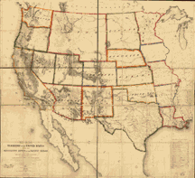 Map of the territory of the United States from the Mississippi River to the Pacific Ocean. Drawn by E. Freyhold (1858) |
Land Grants
The second half of the nineteenth century was the era of railroad land grants. Between 1850 and 1872 extensive cessions of public lands were made to states and to railroad companies to promote railroad construction. Usually the companies received from the federal government, in twenty- or fifty-mile strips, alternate sections of public land for each mile of track that was built. Responsibility for surveying and mapping the grants fell to the U.S. General Land Office, now the Bureau of Land Management. Numerous maps of the United States and individual states and counties were made which clearly indicated the sections of the granted land and the railroad rights-of-way.
Land grant maps were frequently used by land speculators to advertise railroad lands for sale to the public. As early as 1868 most western railroads established profitable land departments and bureaus of immigration, with offices in Europe, to sell land and promote foreign settlement in the western United States. Consequently, the Library's collections also include some foreign-language maps aimed at both the immigration already on the East Coast and the prospective one in Europe.
Competition between speculators may have led to the idea of the distortion of railroad maps to emphasize one state, area, or line to the advantage of the advertiser. This idea, derived from the government land grant maps, may have been perpetuated by the mapping of the Illinois Central Railroad after it was granted land along its path in 1850. In John W. Amerman's book entitled The Illinois Central Rail-Road Company Offers for Sale Over 2,000,000 Acres Selected Farming and Wood Land (New York, 1856) appears an "Outline map of Illinois" which emphasizes the Illinois Central Railroad by a heavy black line, with stations placed evenly along the line to give the illusion of proximity of towns along the lines. This practice of manipulating scale, area, and paths of railroads became common practice in advertising maps of the 1870s and early 1880s and in railroad timetable maps.
Map Publishing Firms
Perhaps 30 percent of the commercially produced railroad maps were published by the New York City publishing house established by Joseph Hutchins Colton in 1831. This firm was known the world over for the quality, quantity, and variety of its publications, including maps, atlases, and school geographies. Henry Varnum Poor, in the introduction to his History of the Railroads and Canals of the United States of America, commends the series of Colton's railroad maps which illustrate his work. "All the maps," Poor wrote, "are drawn and engraved under the supervision of G. Woolworth Colton, Esq., whose diligence, accuracy and extensive information are sufficient guarantee for their correctness."
Indeed, Colton's maps from the early 1850s to the last decade of the century, most of which were subtitled "Colton's Railroad and Township Map," surpassed in quality and quantity other maps published in the nineteenth century. Other reputable map publishing firms of the period include Asher & Adams of New York, James T. Lloyd and Company of New York and London, Matthews-Northrup and Company and J. Sage and Sons of Buffalo, Gaylord Watson of New York and Chicago, and later in the century, the Chicago firms of Rand McNally, Poole Brothers, and George F. Cram. The Poole and Cram firms originally stemmed from the Rand McNally Company.
Following the consolidation and rapid growth of North American railroads after the financial panic of 1873, many commercial maps were produced to show the spreading network. One company signaled its emergence into this field by announcing in January 1873 that "the house of Rand, McNally & Co., beg leave to inform their railroad friends, and the patrons of the [Railway] Guide generally, that they have lately made extensive additions to their engraving department, and are now prepared to execute Map and all kinds of Relief Plate Engraving [i.e., wax engraving] in the very highest style of the art." Rand McNally's output in the late nineteenth century rivaled the volume of maps, guides, illustrated timetables, and atlases produced by Colton.
In 1858 William H. Rand, a native of Boston, established a printing office in Chicago and employed as a printer Andrew McNally. By 1868 Rand and McNally formed a partnership which soon acquired a reputation for printing railroad publications. In 1871 they introduced the Rand McNally Railway Guide. Less than a year after their business was destroyed in the 1871 Chicago Fire, the company's first two maps appeared in the December 1872 issue of the Guide. In response to the need by the railroads for maps, in timetables and other publications, Rand and McNally opened a map department in late 1872. With the adoption of the wax engraving process, followed in May 1873 by the employment of a color printing process, the company's reputation as one of the world's leading commercial mapmaker was established.
A major accomplishment of Rand McNally was the publication in 1876 of the "New Railroad and County Map of the United States and Canada. Compiled from Latest Government Surveys, and Drawn to an Accurate Scale." That same year, the company used the plates from this map to produce its famous Commercial Atlas and Marketing Guide, which was issued in its 129th edition in 1998. The map and the Business Atlas, as it was then known, required the services of ten compilers and engravers for nearly two years and cost about $20,000. Today the atlas continues to be an indispensable reference tool for the business world and the librarian, for it contains the most complete index to place names in the United States, as well as useful railroad information. There is a complete list of railroads in the United States, mileage and distance tables, freight and passenger service information, and a summary of the current status of major mergers. A map of the principal railroad network is also included, along with the state maps that show and list the railroads serving each state.
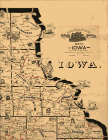 Northeastern portion of the map of Iowa by Frank H. Galbraith. 1897 This is one of several maps he designed to assist railway clerks in sorting the mail. |
Between 1882 and 1891 Rand McNally produced "elephant-size" maps at the scale of 1:506,880 or 1 inch to 8 miles, in twelve panels which formed a map more than 10 x 15 feet in size. The several editions of the map, which depicts the country from the East Coast to the 105th meridian of longitude, are entitled "Rand McNally & Co's New Railroad Junction Point and County Map of the Eastern & Middle States Prepared from Latest Government Surveys, and Verified by the Working Time Tables of the Various Railroads. Drawn, Engraved, Printed, Colored by Hand and Published by Rand, McNally & Co., Chicago." It shows county boundaries, all railroad junctions, and all railroads. This is probably the map which George H. Heafford stated was "frequently posted on the out-houses, dead-walls and fences of our large cities."
Early Twentieth Century
Not all the commercial mapping ventures of the late nineteenth and early twentieth centuries represented large and diversified operations. Several interesting manuscript maps of the mid-western states portray routes of the "Railway Mail Service" and locate working post offices. These maps were designed by an enterprising Chicago railway mail clerk, Frank H. Galbraith in 1897.
The maps were devised to serve as memory aids for employees of the Railway Mail Service and the U.S. Post Office Department in quickly locating counties, routes, and post offices in the several states. The maps were not published but were rented, on a fee basis, to practicing or prospective postal workers.
Railroad map production continued at a strong pace into the early twentieth century, until expansion of the network was completed. It declined, slowly, after the peak of railroad building. The largest decline was in individual promotional maps and surveys as lines became abandoned or consolidated. General railroad maps, depicting continental and national areas and using the basic style developed in the previous century, continued to be popular until the beginning of World War II.
Today, separately published maps of individual consolidated systems and small-scale maps printed in timetables and atlases, such as Rand McNally's Handy Railroad Atlas of the United States (Chicago, at least 11 editions from 1937-1980), continue to reflect the influence of mapping and printing styles set in the nineteenth and early twentieth centuries.
This introduction was adapted from Andrew M. Modelski, Railroad Maps of North America: The First Hundred Years (Washington: Library of Congress, 1984), pp. ix-xxi, which represented a revision of the "Introduction"to Railroad Maps of the United States, compiled by Andrew M. Modelski (Washington: Library of Congress, 1975), pp. 1-14.