Laminated Classroom Wall Maps
Laminated Classroom Wall Maps are designed for durability and practicality, making them ideal for educational settings. Featuring clear labeling and vibrant colors, these educational wall maps provide detailed views of world geography, United States regions, countries, continents, and more. The laminated surface allows for easy write-on and wipe-off functionality, perfect for interactive lessons and repeated use. These classroom maps are a great budget friendly alternative to spring roller maps and are available in a variety of options, select a paper map poster print, laminated map, wood rail mounted map, peel & stick wall decal map, or framed canvas map. Our large selection of laminated maps for the classroom includes a wide range of maps for every grade level. Explore our collection to find the perfect classroom map that combines learning, convenience, and long-lasting quality.

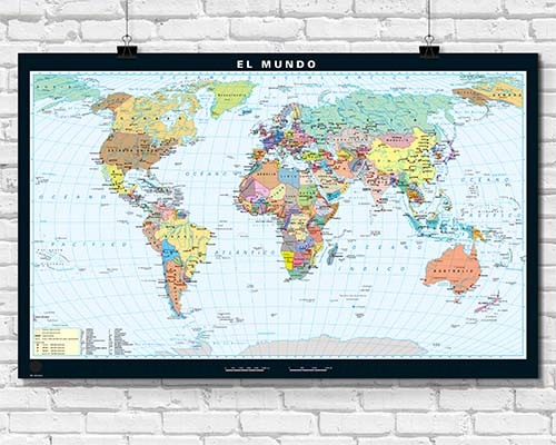
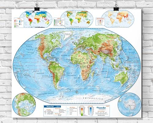
World Laminated Classroom Wall Maps
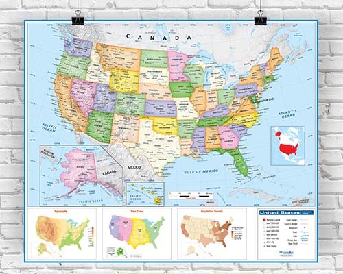
United States Laminated Classroom Wall Maps

US & World Laminated Classroom Wall Map sets
Foreign Language Wall Maps

Laminated Classroom Maps of Continents
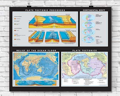
Earth Science Posters & Maps
Laminated Classroom Wall Maps by Grade Level
Yes. Laminated classroom wall maps are specifically designed for use with dry-erase markers. Teachers can circle countries, trace routes, highlight regions, and annotate directly on the surface during lessons. The marks wipe clean for repeated use day after day.
Wet-erase markers can typically be used on laminated surfaces and offer the advantage of not accidentally rubbing off during a lesson. They require a damp cloth to remove rather than a dry eraser.
Laminated classroom maps are designed for years of continuous institutional use. The lamination resists tearing, moisture, and repeated marker use. Many schools report using the same laminated maps for years of daily classroom instruction before replacement is needed.
For dry-erase marker, use a standard dry eraser or soft cloth. For stubborn marks, a damp cloth with mild soap removes residue without damaging the lamination. Avoid abrasive cleaners or solvents. Regular cleaning after each use prevents ghost marks from building up over time.
The Laminated Classroom Wall Maps collection is organized by grade-level appropriateness. Options range from simplified maps with clear labeling for younger students to highly detailed reference maps for middle school, high school, and college instruction. Maps cover world, US, continent, and earth science topics.
Laminated classroom maps cover world geography (political and physical), United States geography, individual continents, earth science topics, and foreign language maps. Both world and US maps are available in multiple complexity levels to match curriculum standards and student reading levels.
For a classroom of 30 students, a map at least 48" to 60" wide provides visibility from all seats. Larger formats ensure that state names, city labels, and geographic features are readable even from the back of the room. Spring roller mounting saves wall space when the map is not in active use.
Yes. Laminated maps can be paired with spring roller pull-down mechanisms for convenient classroom use. The map retracts into the roller housing when not needed, saving wall space and protecting the map surface. See the Spring Roller Pull-Down Maps collection for mounted options.
Yes. School purchase orders are accepted from schools and government agencies in the US and Canada. Orders are processed immediately and invoiced under net 30 payment terms.
Yes. Foreign language laminated classroom maps are available in Spanish, French, and other languages for world language programs, bilingual classrooms, and international curricula. These feature place names and labels in the target language while maintaining the same durability and dry-erase compatibility.